


Istituto Geografico Militare [Military Geographic Institute (IGM)]
An official organ of the State for cartography, the Institute is heir to the military Topographical Offices of the States existing prior to Italy’s unification. It was established in 1872, under the name of Istituto Geografico Militare, to satisfy the geodetic, topographical and cartographical needs of the Kingdom of Italy. In 1882 it assumed its present name. Since its foundation its activity has consisted of geometric classifying of the territory, land surveying, medium-scale map-making and producing documentation for the public.
Various collections are conserved by the Institute. The cartographic collection (around 36,000 items) is divided into the old papers of the pre-unification States (up to about 1860); the IGM "historical series", which includes maps of the entire national territory on the scale of 1:25,000, 1:50,000 and 1:100,000, arranged from the Unification of Italy to the 1930s; maps of the former Italian colonies and of places pertinent to Italian interests (series without a homogeneous cover).
The collection of copper plates (2,615 items) comprises engraved plates, mainly from the 19th century. Some of these (the most valuable, with burin engraving) come from some of the pre-unification States, while the remainder (examples of the technique of chemical etching in use in the late 19th and early 20th centuries) are of IGM production.
The photographic collection consists of two groups: the "modern" (after 1954) aerophotograms archive, containing about 180,000 photographs; and the "historic" photographic archive (from the origins up to 1954), which includes approximately 62,000 aerophotograms of the national territory, about 70,000 panoramic and terrestrial shots and about 118,000 aerophotograms of the territories of Italy’s former colonies.
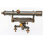
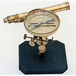
Lastly, the Institute possesses a collection of instruments (around 400 items) for geodetic surveying, astronomy, topography and physics. The original nucleus was formed by uniting the instrumentation existing prior to 1861 at the topographic departments of the pre-unification States, the Kingdom of the Two Sicilies and Sardinia in particular. These are mainly French, British and German instruments. Later, with the establishing of the Institute, the collection was enriched, often with instruments designed by its own personnel and constructed in the IGM mechanical workshop. The collection is continuously incremented by the instruments that become technologically obsolete over the years.
The greater part of the collections are not on display. The objects exhibited are placed in cabinets and display cases in the corridors (papers) and hallways (instruments). For the purpose of conservation, the charts exhibited have been replaced with copies.
The Library of the Institute (120,000 volumes) contains texts related to the activity of the IGM, 750 atlases and a rich newspaper and periodical numbering some 700 titles. Annotated catalogues, cards describing individual objects, and thematic cards are provided.
****************************
Texts by Antonella Gozzoli
English translation by Catherine Frost
Last update 18/gen/2008