


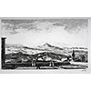
Arezzo and Valdichiana
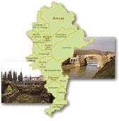
The Valdichiana, along with the Valdarno, is one of the few vast plains in Tuscany. For this reason, since antiquity, the region has been the object of extensive agriculture and specialised production activities such as ceramics. The optimal use of the territory required an efficient water drainage system, which was already laid out in the Etruscan-Roman age and developed from the Middle Ages to the present day.
 = libraries and archives
  = scientific research centers
  = memorial places of scientists
 = public health places
 = places of science and worship
 = places of technology
  = museums and collections
  = villas and gardens of science
Among its numerous motives of interest, the Museo Archeologico Nazionale located in the heart of Arezzo boasts a large section devoted to sigillata ceramic, a typical production of early-imperial Arezzo that was widely exported throughout the Mediterranean basin.
 Museo Archeologico Nazionale Gaio Cilnio Mecenate
Hosted in the former monastery of San Bernardo, built around the mid 14th century on the remains of a Roman amphitheatre by the Benedictine Olivetan order, and restructured in the 17th and 18th centuries, the Archaeological Museum of Arezzo houses a vast collection of ancient artefacts, mainly from the Etruscan and Roman epochs. It contains a large number of very famous pieces, such as the splendid Attic krater by Euphronios and, from the scientific viewpoint, is especially important for the rooms devoted to the production of Arezzo terra sigillata. This very fine dining-table ceramic, has decorations in relief and is coated with a coral red paint. Produced in series with dies, it was popular from the mid 1st century B.C. to the middle of the following century. The exhibition illustrates its production techniques, and rooms VI, VII and VIII present pieces from the main workshops, of which we can cite those of M. Perennius and C. Ateius.
(Elena Fani)

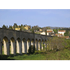
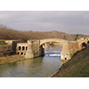
A short distance from the historical centre are the arches of the sixteenth-century aqueduct designed by Giorgio Vasari, which are still visible and in an excellent state of repair.
 Aqueducts of Arezzo
Perceived since the dawn of time in every urbanised centre, the problem of water supply was also confronted in Arezzo since its very origin. There were Baths in the Roman epoch, but very few traces remain today of the aqueduct that we presume supplied them. The so-called Vasari aqueduct, built between 1593 and 1603, conformed quite well to the structure of the Arezzo territory. In the lower part of the valley, the aqueduct passed along a series of arches, while an underground canal transported water through the hill to the foot of the fortress of Arezzo. In place of blow-holes in the underground canal, the height of the water pipe was considerably increased, and the waters flowing from the mouths of the Public Fountain supplied the fountains in Piazza di San Agostino, a large wash-house and the fulling-mills in the area.
The arches of the Vasari aqueduct can still be admired today in good repair on the north-eastern outskirts of Arezzo in the locality of "Gli Archi". Between 1925 and 1929, the Commune of Arezzo ordered the construction of the new "Buon Riposo" Aqueduct in order to supplement the previous conduit in case of necessity. In 1930, the Fraternita dei Laici, owner of the Vasari aqueduct, surrendered it to the Commune so that the system of water management could be unified.
(Mara Miniati)

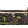
Also tied to the territory’s hydraulic engineering is the complex known as the Chiusa dei Monaci Sluice, an impressive structure built in several stages between the 12th and 18th centuries, reached via the Arezzo-Battifolle road, and intended to regulate the flow of the waters of the Chiana.
 "Chiusa dei Monaci" Sluice
The "Chiusa dei Monaci" sluice was built around 1151 by the friars of the monastery of Santa Flora and Lucilla of Arezzo as a weir on the Canale Maestro (north of Arezzo), with the function of regulating the outflow of waters from the marshland of the Valdichiana to the River Arno. In 1388, the level of the sluice threshold was lowered in the attempt to improve water outflow. It became one of the main structures in regulating the waters of the Chiana, but between 1547 and 1607 it was overrun by floods at least ten times. To improve the conditions of the swamp area, it was planned to lower the threshold again in the late 16th century. This intervention, however, encountered the opposition of the Florentines, worried that the waters of the Chiana that flowed into the Arno would increase the risk of floods in Florence. In 1635, under commission to the Florentines, Enea Gaci from Castiglione elaborated a project which, among other interventions, provided for the destruction of the sluice, but this was never realised due to the opposition of Evangelista Torricelli.
New works on the sluice were planned and, in several cases, carried out between the 18th and 19th centuries. In the mid 18th century, Grand Duke Peter Leopold of Lorraine sent Leonardo Ximenes to Valdichiana in order to develop a reclamation project. Ximenes suggested that the level of the sluice be lowered even more, but this time too, the project was not realised, so as to avoid compromising the navigability of the Canale Maestro. The same type of intervention was suggested by Vittorio Fossombroni in the late 18th century. In 1838, Alessandro Manetti again proposed to lower the sluice by more than three metres and to build a drain beside it. Today, the structure testifies to the Lorraine intervention in Valdichiana, and is part of the "Chiusa dei Monaci" Park, located at the end of the Canale Maestro della Chiana.
(Graziano Magrini)
Taking the motorway slip road in the direction of Viciomaggio, and continuing along SP21, after about 12 km lies the town of Civitella, a territory with numerous works tied to the century-old struggle to reclaim the valley line.
 Land reclamation projects in Valdichiana
The Valdichiana, whose name derives from the river Clanis (today's Chiana), is mentioned as the Clanis Aretinum basin by Pliny the Elder is his Historia Naturalis. The watercourse received waters from Casentino and from numerous torrents that gradually turned a vast area into swampland. The Etruscans carried out the first initiatives aimed at regulating the waters in the area to make the land arable and the Chiana River navigable down to the Tiber. The valley was long considered so fertile and productive that it was still known as the "granary of Etruria" in Roman times. The Romans continued the work in the valley, building fish-weirs along the course of the Chiana to improve the fishing conditions and make the area more wholesome. The Valley was also involved in the building of the Cassia military road, which crossed it longitudinally. The last years of the Republic saw the beginning of a slow decline, during which the whole area became swampland, due also to the progressive inversion of the course of the Chiana from the Tiber to the Arno. Between the 10th and the 13th centuries, isolated attempts at draining the swamps were made by the monks, who had only inadequate means. The most important initiative was the construction of the Chiusa dei Monaci (Monks' Dam) in 1151. In the 13th century the place became insalubrious and desolate, and as such it is recorded by Dante Alighieri in the Divine Comedy (Inferno - XXIX, 46-47; Paradise -XIII, 23).
In 1338 the government of Arezzo launched an attempt at land reclamation that called for the construction of the Fossatum Novum, a longitudinal canal of about six kilometers. In 1492 the Papal State and the Florentines discussed other projects, not implemented due to the opposition of Siena. Between 1502 and 1503, Leonardo Da Vinci drew up, at the order of Cesare Borgia (Il Valentino), a study for hydraulic works in the territory that called for the construction of a navigable canal along the Arno down to Pisa; famous is his birds' eye view of the Valdichiana (Windsor Castle, Royal Library, no. 12278). In 1551 Cosimo I de' Medici commissioned the engineer Antonio Ricasoli to make a thorough survey. A general land reclamation project would be possible only when all of the territories had been brought under Medicean power. Under Ferdinand I a systematic initiative of draining the swamps began and the first great grand-ducal farms were built on the reclaimed land. Later, projects were requested even of Galileo Galilei, Vincenzo Viviani and Evangelista Torricelli. In particular, Torricelli, who had strongly opposed the project of Andrea Gaci from Castiglione, drew up a hydrodynamic plan, which was not implemented, in which he declared the filling-in method to be the only suitable means for land reclamation in the valley.
After several minor initiatives, work resumed under the reign of Grand Duke Peter Leopold of Lorraine who, in 1763, commissioned Leonardo Ximenes to draw up a project for land reclamation in the area. The project was not implemented due to the opposition of the mathematician Tommaso Perelli, who was in turn to plan and carry out an initiative of his own. Between 1789 and 1827 it was the turn of Vittorio Fossombroni, who planned to give a regular slope to the valley by means of filling-in and to govern the course of the streams and rivers. The work was then put under the direction of the Florentine engineer Alessandro Manetti who, from 1838 to 1859, planned and carried out numerous initiatives, among them the realization of a basin with an artificial waterfall six meters high. After the Unification of Italy, further initiatives were carried out by Carlo Possenti, inspector of the Arezzo Civil Engineers Corps, who completed, with some modifications, the work begun by Manetti. By the 1930s, land reclamation could be considered completed.
Some buildings dating from the land reclamation period are of great interest. Beautiful, for example, is the imposing estate of Rugliano, built in the 18th century over an earlier Roman construction. It can be visited along a fascinating itinerary that leads from Pieve al Toppo to Viciomaggio on the Siena-Arezzo State Road 73.
(Graziano Magrini)
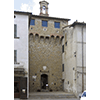
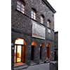
Continuing south along SP22, you reach the town of Monte San Savino where an ancient medieval castle houses an exhibition dedicated to local ceramics for home use.
 Museo Comunale della Ceramica Popolare
Hosted in several rooms of the medieval fortress of Cassero (14th century), the Museum documents the old production of ceramic artefacts for domestic and folk use, typical of Mount San Savino. The exhibition apparatus also presents artefacts found in the course of restoring the Cassero fortress, and others in majolica from the fortress of Ciggiano. The exhibition is completed by a small archaeological section.
(Graziano Magrini)
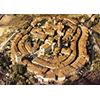
Along the road that leads to Trequanda, we advise a detour onto SP19 to then proceed towards of Lucignano, a unique village for its layout in concentric circles.
 Palazzo Comunale of Lucignano
Probably of 13th century origin but substantially rebuilt in the 14th, the Palazzo Comunale of Lucignano (the former Palazzo Pretorio) bears on one side of the building an antique mechanical clock dating from 1730, placed there by the Roman craftsman Antonio Giacchei as replacement for an earlier one. The dial has six Roman numerals in copper, originally gilded, applied directly to the façade. The frame, in wrought iron of the "a castello" type, was repaired for the last time in 1954. On the ground floor of the Palazzo is the Lucignano Municipal Museum, which displays, among its many art objects, the two weights from the ancient clockworks.
The Palazzo is inserted in a remarkable urban context. With its characteristic elliptical shape with concentric ring streets, the fortified village of Lucignano constitutes one of the most interesting examples of a medieval town surviving to our own day. Located in a zone of strategic importance, it was long contested by the cities of Arezzo, Siena, Florence and Perugia for domination over the Valdichiana. Surrounded with walls by the Sienese already in 1371, the town was further fortified by the Florentines with the construction, around 1558, of a fortress at the order of Cosimo I de' Medici, attributed to the architect Bernardo Puccini. In addition to the Fortress and the Rocca, extensive sections of wall are still visible in the town, with a broad escarpment, three of the original doors and two towers with projecting defensive structures (a gallery in masonry).
(Elena Fani)
Finally, on reaching the locality of Petroio, after travelling in sequence SP 19, SP14 and SP71 for a total of about 20 km, the itinerary ends with a visit to the Museo della Terracotta, which presents an interesting section dedicated to the local techniques of ceramic manufacture.
 Museo della Terracotta
Founded in 2001 and hosted in the Palazzo Pretorio of Petroio, the Museum is part of the Sienese Museum System. It gathers the evidence of the town’s production history, dedicated to the traditional manufacture of terracotta products. In addition to various kinds of objects in terracotta, it also possesses extensive documentation on the techniques of manufacture. The Museum visit can be integrated by itineraries through town and the surrounding territory.
(Stefania Mangia)
****************************
Texts by Elena Fani
English translation by Victor Beard
Last update 22/feb/2008