


Maremma - Reclamation
For centuries, the development of Maremma and, in particular, of the plain area on the coast, was influenced by seriously unhealthy conditions owing to its swamp areas. While the Medici had already carried out several targeted interventions in the area, especially thanks to the institution of the Ufficio dei Fossi di Grosseto, it was only with the Lorraines that the first, efficient measures were taken for the complete reclamation of Maremma.
 = libraries and archives
  = scientific research centers
  = memorial places of scientists
 = public health places
 = places of science and worship
 = places of technology
  = museums and collections
  = villas and gardens of science
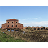
A mandatory point of departure to visit the most significant emergences concerning the history of the territory’s reclamation is, without a doubt, the Museo Multimediale Casa Rossa in Castiglione della Pescaia. The building is tied to the name of the scientist responsible for the most important projects for reclaiming the area, Leonardo Ximenes.
 Museo Multimediale - Casa Rossa Ximenes
This impressive structure, also known as Casa Rossa (red house), was built around 1765 on a project by the Jesuit Leonardo Ximenes, instructed by Grand Duke Peter Leopold of Lorraine to attend to the reclamation project of the Maremma area of the province of Grosseto. Ximenes’ projects marked one of the most important phases in the works of reclamation. The scientist argued that it was not necessary to completely drain the lake of Castiglione, as had been previously attempted, but that its regimen had to be properly controlled so as to avoid stagnation, allowing it to continue to be an important source of income and occupation (fishing, hunting, transport, utilisation of swamp vegetation).
Casa Rossa is a fine evocation of Ximenes’ commitment in the attempt to reclaim the area. Above the three large arches that characterise the structure, the large hoist room housed the machines and pulleys used to manoeuvre the floodgates, the middle one of which weighs about 40 quintals (4000 kilograms). The structure made it possible to control the outflow of the large canal known as the Canale Reale or Maestro, which permitted the exchange of the lake waters. This infrastructure served hydraulic and sanitary purposes, to drive mills and presses, water livestock, assure canal practicability and permit the rational exploitation of fishing, thereby permitting the lake to reclaim its old role as the centre of fish supplies for the grand duchy of Tuscany.
Still in good repair, the building houses the fascinating "Casa Rossa Ximenes" Multimedia Museum, which constitutes the entrance gate to the Castiglione della Pescaia Swamp ("Diaccia Botrona" Provincial Nature Reserve), one of the most important marshlands in Europe. The multimedia itinerary permits, among other things, the live observation of the animals in the area, thanks to television cameras activated from technological stations that reproduce images on large screens.
(Graziano Magrini)

Also in Castiglione della Pescaia, 1 km inland, the sluice on the San Leopoldo canal is one of the barrage works conceived to channel and discharge the waters of the large Castiglione Lake into the sea.
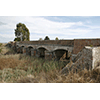 Bonifica del Lago di Castiglione - Chiusa sul Canale San Leopoldo
The flat coastal area of today’s province of Grosseto was the swampland of Tuscany that for centuries posed the greatest difficulties from the viewpoint of environmental reclamation. The exploitation policies of the Medici age aimed at boosting agriculture and pasturage in the area, though the presence of the large Castiglione Lake, which in the 16th century had an extension of approximately 50 km 2 , strongly limited development. At the same time, however, fish farming guaranteed the government one of the most substantial incomes of its entire landed patrimony.
Grand Duke Ferdinando I de’ Medici attended to the realisation of many hydraulic works, in 1592 instituting the Canals Office of Grosseto, which was the most important measure adopted to remedy the area’s hydraulic precariousness. Indeed, for the first time, the ruler appointed a local decentralised authority to coordinate, control and define reclamation initiatives in a province that was scarcely populated and perpetually devastated by the incursions of wild livestock that caused the systematic destruction of any and all hydraulic constructions.
During the Lorraine Regency, a team of engineers launched the integral reclamation plan of Maremma, which was subsequently supported by Grand Duke Peter Leopold. With its realisation entrusted to Leonardo Ximenes who described its features in his famous work, Della Fisica riduzione della Maremma senese, this project abandoned the previously attempted idea of filling Castiglione Lake, and instead aimed at exploiting it for production by means of a systematic and rational regulation of its waters. "Refreshment" canals were dug in order to allow the regulated introduction of waters from the Ombrone River into the lake, so as to avoid stagnation. Furthermore, in order to control and facilitate the outflow of lake waters towards the sea, the Floodgates Building was constructed on a project by Ximenes, and the Canale Reale or Maestro was excavated nearby. Pietro Ferroni, who succeeded Ximenes in 1781, retrieved the old project to drain Castiglione Lake and carried out its partial filling. The Lake’s definitive filling was carried through in the course of the first half of the 19th century, thanks to the study by Vittorio Fossombroni, which implemented the most impressive reclamation measure of Maremma in the provinces of Pisa and Grosseto. Launched with a decree by Grand Duke Leopold II on November 27, 1828 and set forth by Fossombroni in his famous, Memoria sulla Grossetana [Memorial on the Grosseto Territory], the project was carried out under the technical direction of Alessandro Manetti. The lake water was collected in five reclamation basins, and then emptied into the sea by means of three specially excavated effluents equipped with sluice-gates: the Bilogio, San Leopoldo (still visible today) and San Rocco. The beds of various canals were dug, little subterranean tanks were built and the tract of the Via Emilia-Aurelia between Cecina and Grosseto was modified: using the most sophisticated technologies and with a considerable outlay of human and economic resources, it was thereby possible to give a decisive turn to disposing of this difficult territory.
(Graziano Magrini)
Of more recent construction, Tura Bridge was built to regulate the water of the Ombrone River. It is located just a little less than 20 km away near the hamlet of Istia d’Ombrone.
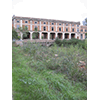 Tura Bridge
Tura Bridge, also known as Steccaia and built in 1829 on the right bank of the Ombrone River, is one of the many hydraulic works between Grosseto and Castiglione della Pescaia which offer significant material evidence of a phase of reclamation of Maremma, mostly promoted during the Lorraine period and carried out by worthy scientists and technicians.
By means of the appropriate machinery, Steccaia made it possible to manoeuvre the complex system of sluices and floodgates along the final tract of the Ombrone River and regulate its waters, thereby making it possible to recover land to destine to agriculture.
Despite its present precarious condition, the monumental structure of Steccaia with its hydraulic works and fascinating architectural features still evokes the daring technical undertaking which, with great efforts, led to the successful reclamation of the area.
(Graziano Magrini)
Finally, if you wish to admire what remains of an ample reclamation area, we advise a visit to the Maremma Natural Park, in the lee of the Uccellina Mountains.
 Parco dell'Uccellina
The first protected area of the Region of Tuscany, the park was born in 1975 to preserve the area’s environment of great natural value. It spreads out for approximately 20 kilometres along the coast from Principina a Mare to Talamone, and is one of the numerous, fascinating nature reserves in the province of Grosseto.
North of the Ombrone stream lies the vast Palude della Trappola swamp, while the Uccellina Mountains rise to the south, an area which preserves traces of human presence dating back to the Upper Palaeolithic and Bronze ages. Several watchtowers were built on strategic locations between the 11th and 16th centuries to defend the coast from incursions.
The Palude della Trappola is what remains of a vast wetland reclaimed by order of Leopold II of Lorraine. A system of drainage canals crosses both the swamp and the pinewood, planted around 1830 by the Grand Duke to protect the cultivations behind it.
The Park Information Centre is located at Marina di Alberese where scheduled buses serve the locality of Pratini, point of departure for various wonderful itineraries.
(Graziano Magrini)
****************************
Texts by Elena Fani
English translation by Victor Beard
Last update 25/feb/2008