

Cartography in Tuscany
The primacy that cartography had since the Renaissance survives still today in the Istituto Geografico di Firenze, the principal study centre of the territory in Italy. The careful reproduction of space according to increasingly more rigorous scientific criteria also led to the realisation of veritable works of art that embellished the walls of grand-ducal centres of government.
 = place
 = biography
 = instrument
 = multimedia
 = book
 = manuscript
 = thematic itinerary
 = geographic itinerary
 = galileian itinerary
 = leonardian itinerary
 = istitution
 = application
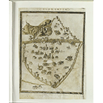
The Map of Piero del Massaio
The tradition of nautical maps produced between the 13th and 14th centuries, plotted using the compass and intended for navigation and maritime commerce, was updated around the mid 15th century on the basis of astronomical and geometrical criteria suggested by the greatest geographer of antiquity, Claudius Ptolemy. Following these principles, Piero del Massaio from Florence drew the regional map of Tuscany. The representation of the territory as a physical and political entity, and no longer as simple coastal boundaries, marked the birth of modern cartography.

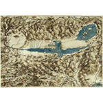
The Image of the City
Piero del Massaio also had the merit of inaugurating urban cartography. To the views of the city in paintings and frescoes of the 14th and 15th centuries, he offered a map of Florence with her principal buildings enclosed by the walls. In the late 15th century, in his cartographical workshop on Costa San Giorgio in Florence, painter and engraver Francesco Rosselli drew and engraved the Veduta della Catena: for the first time, the city was depicted in its entirety without selective choices of buildings and monuments. The map by Rosselli, also author of splendid Ptolemaic planispheres, was taken up in many cosmographies published in northern Europe between the 15th and 16th centuries.
Leonardo da Vinci and Girolamo Bellarmato
The development of the measuring and surveying techniques promoted by the Renaissance "engineers" and the fortunes of the work by Piero del Massaio were at the basis of the cartographic experiments of Leonardo da Vinci and Girolamo Bellarmato. Already in his paintings and drawings, Leonardo depicted the landscape with a surprising scientific spirit. The meticulous cartographical sketches represented the prelude of veritable maps, where art and science, drawing and measurements came together to attain extraordinary results. The Chorographia Tusciae by military engineer from Siena Girolamo Ballarmato was also founded on the direct observation of the territory. Printed in Rome in 1536, the map was taken up in the course of the century by many famous cartographers.
Cartography and Political Power
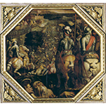
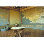
In the mid 16th century, the new demands of political power imposed a different role on the figure of the cartographer, no longer or, not only, a painter, but also a scientist and engineer. From 1562 to 1575, grand-ducal "cosmographer" Egnazio Danti frescoed the Cosmografia in the "Guardaroba" (today’s Sala delle Carte Geografiche) in Palazzo Vecchio, and between 1580 and 1583, he executed Etruria in the Galleria Vaticana del Belvedere. These were the years in which Medici power sang its own praises in the most sumptuous decorative apparatuses. In 1563, on the ceiling of the Salone dei Cinquecento in Palazzo Vecchio, Giorgio Vasari portrayed episodes of the war between Florence and Pisa and between Florence and Siena, leaving significant pictorial tokens of urban landscape painting.


Stefano Buonsignori and the Portrayal of the City
In 1589, under commission to Ferdinando I de’ Medici, the cosmographer to Grand Dukes Francesco I and Ferdinando I de’ Medici, Olivetan monk Stefano Buonsignori painted the Florentine and Sienese domains in the Sala delle Matematiche degli Uffizi. The intention of these large maps was to celebrate Medici power, placing emphasis on political-military and administrative interests. Stefano Buonsignori was author of one of the most famous and fascinating maps of Florence. A refined axonometric and perspective technique enabled him to offer an extraordinarily precise image of the city from above. On Buonsignori’s model, painter Francesco Vanni drew his map of Siena in 1595; in those same years, Achille Soli made a map of Pisa and an anonymous author made one of Lucca.
Cartography in the 17th Century
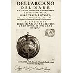
Buonsignori’s maps and Bellarmato’s experiment were the models followed by cartographers for a long time: the Etruria vetus et nova which Theodor Vercruyss engraved in 1724, was inspired by Buonsignori’s map. Pictorial and scientific intentions remained closely bound in seventeenth-century cartography. A model case is the monumental L’Arcano del Mare, a nautical atlas drafted by Englishman Robert Dudley in Florence in the mid 17th century.
Cartography in the 18th Century
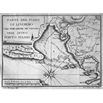
The close relationship between landscape painting and cartography is documented by the map of the Pistoian Mountains by Giovanni Luder in the early 18th century. In the Lorraine age, it became necessary to dispose of a "geographical map" of Tuscany, a product and reflection of the illuminated culture of the territory, testified by numerous and significant reclamations and by the naturalist-antiquarian explorations of Giovanni Targioni Tozzetti. Tuscan map-making production was tied to Lorraine administrative reformism. Maps were made for precise purposes: hydraulic, political-administrative, military, fiscal and sanitary. Maps of vicariates, communities, feuds, and dioceses were in great number, as were also of customs, sanitary, fortification, communication lines, reclamation and waterway layout structures. The so-called "cabreistica" also spread, that is to say the portrayal of possessions or private estates. Former "lecturer of mathematics" in the grand-ducal fleet and "second engineer of the Royal Possessions", Ferdinando Morozzi authored the general map of Tuscany and the map of the "vicariates" in 1768. The Pianta della cittŕ di Firenze, surveyed in 1783, drawn by Francesco Magnelli and engraved by Cosimo Zocchi, updated urban cartography.
The Tuscan Cartographic School
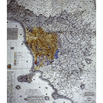
Ferdinando Morozzi, Alessandro Manetti and, especially, Leonardo Ximenes were the protagonists of the development of cartography in the second half of the 18th century, indeed forming a "school" which shortly thereafter was to produce documents of extraordinary importance. The masterpiece of Italian scientific cartography is indeed the Carta Geometrica della Toscana, obtained from life in 1:200,000 scale by Giovanni Inghirami of the Ximenes Observatory and printed in Florence in 1831. This map provided inspiration to the many maps published around the mid 19th century, such as the one published by Girolamo Segato in 1832, the Atlante by Attilio Zuccagni Orlandini in the same year, and the Carta Generale del Granducato di Toscana, printed by Litografia Militare in 1858.
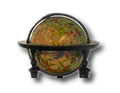
The "Places" of Cartography
Privileged places for a "journey" through antique maps are archives and large historical libraries, whose cartographic documents, when not on show in special exhibitions, can be consulted for reasons of study. To appease scientific curiosity, there is no lack of scenographic settings in Tuscany where it is possible to grasp the evolution of cartography: from the splendid Sala delle Carte Geografiche in Palazzo Vecchio to the Historical Topographical Museum of "Florence as it was", from the Istituto Geografico Militare, official state organ for cartography, to the numerous local museums which never fail to exhibit, whether originals or copies, the historical cartography of their territory.
****************************
Texts by Alessandro Tosi
English translation by Victor Beard
Last update 28/gen/2008