


Maremma - Defence Systems
The fortunate geographic location, in the "centre" of the Tyrrhenian Sea, that the promontory of Argentario occupies, made this area of southern Maremma strategically one of the most important of Tuscany since antiquity. Though the first works of a defensive nature date back to the Bronze Age, it was mainly during the Renaissance that the impressive complex of fortresses, still visible today, developed.
 = libraries and archives
  = scientific research centers
  = memorial places of scientists
 = public health places
 = places of science and worship
 = places of technology
  = museums and collections
  = villas and gardens of science
Most of the powerful military structures located between the lagoon of Orbetello and the promontory of Monte Argentario were built or considerably reinforced as of 1557, when the entire area passed under Spanish rule, entering the State of Presidi. Among these, the splendid Guzman Munitions Depot, which looks onto the lagoon in the Levante area, is certainly worth a visit.
 Ex Polveriera Guzman - Museo Archeologico Civico
A splendid example of Spanish military architecture, the Guzman munitions depot was built in 1692 as part of the fortifications system that, along with the homonymous bastion, protected the capital of the State of Presidi. This stone-roofed structure was outfitted with four obelisks positioned in front of the windows in order to protect the explosive contents from weapon fire. After docking at Talamone, Giuseppe Garibaldi came here to stock up on weapons and ammunition for the Expedition of the One Thousand.
The munitions depot houses the municipal archaeological collection abounding in necklaces, buccaro and stone utensils, which cover a chronological arch from the Villanovan age to the Roman age. The collection is completed by materials from the territory of Orbetello. Particularly interesting, finally, is the copious archaeological documentation found at the Villa di Settefinestre, a splendid example of the villa of a large landed estate of the late-republican and imperial age, the grandiose remains of which lie neglected a few kilometres south of Capalbio.
(Elena Fani)

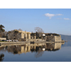
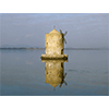
On the opposite side, on Viale Mura di Ponente, another structure tied to Spanish rule can be admired, though born earlier. It is a mill with a circular plan, which was utilised in the past to grind wheat.
 Spanish Mill
One of the symbols of Orbetello, the Spanish Mill is the only windmill left of the series of nine, built by the Sienese and successively restored by the Spanish when the lagoon city became the capital of the little State of Presidi (1557). The mill has a circular plan and, along with the others, was used to grind the flour destined to the city’s inhabitants. Suggestively rising from the lagoon, the building is sited at the beginning of an artificial dam built by Grand Duke Leopold II in 1842 to connect Orbetello to Argentario.
(Graziano Magrini)
Proceeding towards Monte Argentario on SS440, and turning left onto SP2, only 5 km away lies the area of Porto Ercole, a picturesque little sea town, dominated by three grandiose defensive structures: the Fortress, Forte Filippo and Forte Stella.
 Defensive System of Porto Ercole
As of 1557, Porto Ercole, along with Orbetello, Porto Santo Stefano, Talamone, Monte Argentario, and later, Porto Longone, became part of the State of Presidi. Its defensive system is characterised by three principal elements: the Fortress, Forte Filippo and Forte Stella.
Built in the 15th century on a project by Vecchietta, englobing several thirteenth-century buildings, the Fortress was modified in the 16th century under the direction of Anton Maria Lari and Baldassarre Lanci. The walls descend to the sea and, by means of an underground passage, connect the Fortress to the Santa Barbara bastion, built on the port along with Santa Caterina fort (today private property), to strengthen the defensive system.
Forte Filippo (also private property) was built in 1558 on a project by Giovanni Camerini. An elongated quadrangle in shape, it has massive bastions at the corners and is surrounded by a deep trench. With its only entrance being a drawbridge on the eastern side, its batteries of cannons, and precise, eye-level shots of the Santa Caterina Battery, made it an important defensive stronghold.
Forte Stella, which was built in the second half of the 17th century and became a museum in 1999, has quite an original shape: the central nucleus, surrounded by quadrilateral walls with bastions at the corners, has a six-pointed star plan (from which it takes its name). It too, was surrounded by a trench and had a single point of entry.
(Graziano Magrini)
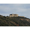
On the southern side of the promontory, approachable via SS440/SP161, the majestic Spanish Fortress of Porto Santo Stefano is the headquarters of a museum dedicated to submarine archaeology and the trades tied to the construction of ships.
 Fortezza Spagnola di Porto Santo Stefano
Probably built around 1560 after the formation of the State of Presidi (1557), the Fortress is a remarkable example of Spanish military architecture. Sited on a hilltop in defence of the port, it has a square plan with barbicans, and rests on a square base formed by two terraces crowned with a series of machicolations. The stone wheels that made the cannon carriages rotate in the 19th century are still visible on the lower terrace. The base houses the warehouses, tanks and quarters for the garrison. Two exhibition sections are currently set up inside the Fortress: one dedicated to the archaeological finds collected on the seafloors of Argentario and Giglio Island; while the other documents the activities of shipwrights, that is shipbuilders.
(Graziano Magrini)
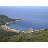
If you have another day’s time, we advise an excursion to Giglio Island where, after a crossing of about 40 minutes, you can visit the well preserved medieval village and follow one of the numerous footpaths, outfitted for brief excursions.
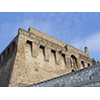
 Giglio Castello
Dominating the island from a height of over 400 meters above sea level, the medieval village of Giglio Castello appears as a small fortified town, surrounded by an imposing belt of walls along which stand ten towers – seven of them rectangular, three circular – entered through an intricate system of gates and avant-corps. Erected by the Pisans during the 12th century, the town passed in the following centuries under the government of the Medici, who reinforced its defensive system, repeatedly attacked by Saracen pirates. Along the narrow streets, distinguished by arches and "balzuoli" (outside stairways giving access to the upper floors of the houses), it is still possible to admire many of the ancient structures created by the military and civil engineering of over five centuries of history. Remarkable for their historical-scientific interest are the grandiose twelfth-century Rocca Aldobrandesca, the circle of walls with its towers and narrow sentry rounds, and lastly, the cistern built at the order of Ferdinand III after the last Saracen raid, courageously repelled by the inhabitants of Giglio in 1799.
(Elena Fani)
****************************
Texts by Elena Fani
English translation by Victor Beard
Last update 30/gen/2008