


Reclamation in Tuscany
The coastal landscape of Tuscany during the Medici age, from the Magra River to Livorno, from the hills of Rosignano to the border with the Papal States, was widely characterised by swamps, ponds, marshes and lagoons, owing to the difficulty of regulating water run-off, due to the only slight slope of the ground towards the sea, and the presence of tomboli and sand dunes, which created difficulties in the land draining. Great inland surface areas were also occupied by marshland. Suffice it to consider the swamps of Chiusi and Montepulciano, that of Fucecchio and the large Lake Bientina.
 = place
 = biography
 = instrument
 = multimedia
 = book
 = manuscript
 = thematic itinerary
 = geographic itinerary
 = galileian itinerary
 = leonardian itinerary
 = istitution
 = application
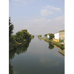
The Medici Policies
Medici policies in this sector were extemporaneous, as they did not follow an organic reclamation programme. Interventions were sporadic, aimed at coping with natural calamities, and often tied to the sovereign’s interests to improve the conditions of the areas where he possessed farms or fish-ponds. These works were therefore intended to carry out exploitation policies that aimed at increasing agriculture, pasturing, fishing and hunting. Major hydraulic works were also realised, in particular along the course of the River Arno which constituted the most important waterway in the Grand Duchy. Of the highly impactive interventions under the communications profile, we must certainly note the excavation of the Navicelli Canal which connected the port of Livorno to the Arno near Pisa.
The Medici were also responsible for instituting special peripheral control centres, such as the Ufficio dei Fiumi e Fossi di Grosseto, instituted in 1592 by Grand Duke Ferdinando I, which was the most important measure adopted to remedy the area’s hydraulic precariousness. For the first time, the sovereign delegated locating and controlling reclamation initiatives to a local peripheral authority in a scarcely populated province, eternally devastated by the incursions of wild livestock, which caused the systematic destruction of all hydraulic manufactures.
As of the 16th century, the reclamation system mainly adopted in the Grand Duchy was by filling, which consisted in raising the level of swampland until reaching the slope necessary to favour natural drainage. Reclamations and hydraulic problems of this type had also been tackled by Leonardo da Vinci who, for several aspects, can be considered the father of modern hydraulic science. Analogous problems later attracted the attention of scientists like Galileo Galilei, Benedetto Castelli, Giovanni Alfonso Borelli, Vincenzo Viviani and Vincenzo Manetti.

The Lorraine Policies
The determined reclamation policy enacted by the Lorraines was a clear manifestation of their will to render the presence of the State visible also through the realisation of works of public interest. The interventions spanned three different phases, becoming increasingly more systematic. In the early years, a type of extemporaneous reclamation like that of the Medici was pursued. As of the mid 18th century, promoted by Grand Duke Peter Leopold, an important debate developed around the hydraulic problems of the territory, and reclamation began to be conceived as environmental. Thus vast areas were recovered for agriculture and human settlements, using important technical and financial means. As of the first half of the 19th century, reclamation became civilising, as it acquired the purpose of improving entire particularly backward areas, created jobs, and was the motive of new faith for the farm owners of these areas.
With the environmental and civilising reclamations, the government therefore enacted a policy aimed at involving the entire population, carrying out integral reclamation projects by which it intended to rehabilitate almost all the degraded territories, so as to assure demographic increase and economic development. Expert engineers were appointed for this purpose, among whom let us recall Leonardo Ximenes, Tommaso Perelli, Pietro Ferroni, Vittorio Fossombroni, Alessandro Manetti, Giuseppe Ruggero Boscovich, Eustachio Zanotti and Lorenzo Nottolini.
Particularly significant were the interventions carried out under Leopold II in northern Maremma, in the Lower Valdarno and in Valdichiana. Using the most sophisticated technologies and great human and economic resources, a decisive turn in the hydraulic layout of these difficult territories gradually succeeded.
Interventions in the 20th Century
A substantial disinterest by the political and administrative organs of the new State was recorded, following the Unification of Italy. The works that had been begun by the last Lorraine grand duke, in particular in the Maremma Grossetana, in the Pisan plains and in the Valdinievole, resumed between the two world wars with new impetus, thanks to the installation of more powerful draining machines. Finally, the period immediately after the world war recorded the progressive completion of reclamations and the prevalent use of lands for intensive agricultural exploitation.
Today, with the institution of reserves and nature parks, the intention is to safeguard the precious palustral oases; at the same time, the various reclamation consortiums guarantee the efficient hydraulic maintenance of the various territories of Tuscany.
Reclamation in Valdichiana
« Just like the sufferings that all the sick
of Val di Chiana's hospitals, Maremma's,
Sardigna's, from July until September
would muster if assembled in one ditch-
so was it here, and such a stench rose up
as usually comes from festering limbs».
[Dante Alighieri, The Divine Comedy, Inferno – XXIX, 46-51]
« a shadow-since its truth exceeds our senses,
just as the swiftest of all heavens is
more swift than the Chiana's sluggishness».
[Dante Alighieri, The Divine Comedy, Paradiso – XIII, 22-24]
In these verses by Dante Alighieri, the Valdichiana is remembered as an unhealthy and desolate place. Though the area had witnessed attempts at reclamation by the Etruscans and by the Romans, the oldest material token of a hydraulic intervention dates to the Middle Ages. This was the Chiusa dei Monaci Sluice, built around 1151 with the function of regulating water run-off from the Valdichiana swampland towards the River Arno. Swept away by floods on several occasions, reconstructed and modified through the centuries, today the structure – now part of the Chiusa dei Monaci Park, situated at the end of the Canale Maestro della Chiana – testifies to Lorraine intervention in Valdichiana. It was the entire basin, however, to engage illustrious minds which expressed opinions or presented projects. One of the characteristic buildings dating to the period of grand-ducal reclamations is the impressive farming complex at Rugliano, built in the 18th century over a previous Roman settlement, and visitable by following a fascinating itinerary which from Pieve al Toppo leads to Viciomaggio by means of the Siena-Arezzo highway no. 73.
Reclamations in the Lower Valdarno
Along the lower Arno basin are two large areas that were object of major hydraulic interventions. In the area of Fucecchio, the "Padule di Fucecchio" Nature Reserve conserves what remains of the old lake-swamp, at the same time promoting naturalistic and historical-environmental learning itineraries. Along the canal of the Usciana, the principal effluent of the lake, the sluice-gate at Ponte a Cappiano is a beautiful and significant token which today substantially preserves the layout ordered by Cosimo I de’ Medici. Efficient reclamations of the area were conducted during the Lorraine period under Grand Duke Peter Leopold and later under Leopold II. A project to completely drain the swamp dating to 1860 was fortunately never realised, while the last interventions of reclamation date back to 1931.
A short distance from the Padule di Fucecchio is the Bientina, in the past also known as Lake Sesto. In part under the control of Lucca and in part under that of the Grand Duchy of Tuscany, it was in the past the largest lake in Tuscany. The history of the area’s reclamation is still today documented by various canals, the elegant sluice-gate building erected on a project by Leonardo Ximenes as of 1757, and sited along a canal, today interred, and by the so-called botte (an underground canal, 255 metres long), built under the bed of the Arno by Alessandro Manetti soon after the mid 19th century.
Coastal Area Reclamations
The coast from north to south was once a succession of wetlands. In the southern part of Versilia, we find Lake Massaciuccoli. It was larger in the past and also included a vast swamp area. Only in the 20th century were vast zones reclaimed that are today part of the Migliarino-San Rossore-Massaciuccoli Nature Park. The park extends along the coast from the southern part of Viareggio up to the Navicelli Canal, including the mouths of the Serchio and Arno rivers, the wetlands of Tirrenia and Calambrone, and the estate of Coltano. It is characterised by pine forests, woods with the typical Mediterranean underbrush, by low-lying wetlands and dunes.
South of Livorno, we find other wetlands belonging to northern Maremma, also known as Maremma Pisana, which for almost a millennium engaged expert engineers. From the wetland of Vada to the plain of Cecina and Bibbona, from the wetland of the Faunal Refuge of the Padule di Bolgheri to the reclaimed Rimigliano Lake, from the former Piombino Lake to the Padule di Scarlino, is a succession of spots that testify to the long history of hydraulic interventions.
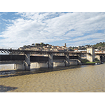
We now enter the Maremma Grossetana which, from the viewpoint of environmental reclamation, was for centuries the most difficult swamp area of Tuscany. The area was characterised by the presence of the large Castiglione Lake, which was definitively filled during the first half of the 19th century. Near Castiglione della Pescaia, it is possible to visit the Casa Rossa, an impressive structure built to control the outflow from the Canale Reale, which permitted the exchange of the lake waters. Today, the building houses a multimedia museum and represents the entrance portal to the Diaccia Botrona Provincial Nature Reserve, one of the most important wetlands of Europe. Along the Bruna River, near the sea, lies Giorgini Bridge whose mechanisms served to avoid the fresh water of the stream mixing with the salt water of the sea. This effect was indeed considered to be one of the main causes of malaria.
Other Lorraine hydraulic works are located between Castiglione della Pescaia and Grosseto, such as Tura Bridge, built in 1829 over the Ombrone River. Further south, the Parco dell'Uccellina is one of the numerous fascinating nature reserves of the province of Grosseto. North of the Ombrone extends the Palude della Trappola, which is what remains of a vast wetland reclaimed by order of Leopold II. A system of canals crosses both the swamp and the pine forest which was planted during the first half of the 19th century by the Grand Duke to protect the cultivations inland. Finally, at the border with Lazio, an extraordinary example of ecosystem inhabited by both sea and fresh water fish, and the nature reserve of Lake Burano, a fascinating faunal sanctuary.
-
 Acquario della Laguna - Museo della Pesca e delle Tradizioni Lagunari [Aquarium of the Lagoon - Museum of Fishing and Lagoon Traditions]
 -
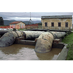
Bonifica del Lago di Castiglione - Chiusa sul Canale San Leopoldo [Reclamation of Castiglione Lake - Sluice on the San Leopoldo Canal]
-
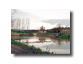
Giorgini Bridge
-
Lake Massaciuccoli
-
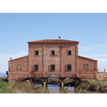
Museo Multimediale - Casa Rossa Ximenes [Ximenes House - 'Casa Rossa' Multimedia Museum]
-
Parco dell'Uccellina [Uccellina Park]
-
Reclamation of Vada
-
Tenuta di San Rossore [The San Rossore Estate]
-
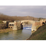
Tura Bridge
****************************
Texts by Graziano Magrini
English translation by Victor Beard
Last update 22/gen/2008