


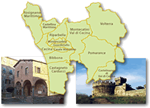
Val di Cornia - Val di Cecina
Though with alternating fortunes, the mineral wealth of the area gravitating around the Metalliferous Hills constituted one of the region’s principal resources in past centuries. Already exploited during the Etruscan epoch, the area’s metalliferous deposits were rediscovered in the Middle Ages and even further valorised in the second half of the 18th century, thanks to the interest of the Lorraine government. Today, following the decline of mining activity in Tuscany, the most exploited resource of the subsoil in the territory consists of borax fumaroles used for the production of geothermal energy.
 = libraries and archives
  = scientific research centers
  = memorial places of scientists
 = public health places
 = places of science and worship
 = places of technology
  = museums and collections
  = villas and gardens of science
To best appreciate this itinerary that develops along a route of some 110 km, we advise you start from the Archaeological Park of Baratti and Populonia, the ancient Etruscan metalworking city, situated 23 km from Piombino.
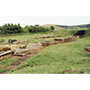
 Parco Archeologico di Baratti e Populonia
The area of the ancient city of Populonia looks out onto the gulf of Baratti, not far from today’s Piombino. The only Etruscan centre to directly face the sea, it owed its fortune mainly to the exploitation of the iron mines of Elba Island. The raw material was transported to the slopes of the hill where the old town was located, and was worked in blast furnaces in order to obtain bars of pure iron.
We can grasp an idea of the volume of the mineral worked in Populonia in more than eight centuries (from the 9th B.C. to the 1st B.C.) from the mass of iron scoria which accumulated in time, more than one million cubic metres. This mass had ended up completely covering the Orientalising necropoli of San Cerbone and Casone.
The thirst for metal during World War I led to the reuse of the Etruscan scoria, still rich in iron material due to the imperfect ancient working process. A company was specially formed, Feromin, which in forty years (extracting activity ceased only in 1969), produced the total elimination of the remains of almost a millennium of siderurgical activity at Populonia. It was precisely by removing the scoria that the remains of monumental tholos and aedicule tombs came to light, and marked the beginning of the rediscovery of the ancient Pupluna.
Still today, beyond the walls of the city proper, near the ancient landing place, we can see the remains of the Porcareccia industrial quarter where, as of the 6th century B.C., the workshops for the transformation of ferrous materials were concentrated.
Today, the entire urban area of the ancient Populonia with its necropoli, industrial quarter and acropolis, has become an archaeological park with a detailed system of signs, which enable a thorough visit. It is also possible to participate in workshops of experimental archaeology where visitors learn the ancient techniques of working stone and ceramic.
The Archaeological Park of Baratti and Populonia is part of a vaster system of parks which extend along the coast and immediately inland. In addition to the areas of natural interest like the Parks of Ripigliano, Sterpaia and Montioni, the itinerary also includes the San Silvestro Archaeological Mines Park.
(Elena Fani)

An interesting complement to the visit to the archaeological area of Populonia is the Parco Archeominerario di San Silvestro, which opened about ten years ago to document the millenarian mining activity of the Val di Cornia. It can be reached from Baratti, taking SP23 and, from Via Aurelia Sud, taking Botro Ai Marmi until reaching Via di San Vincenzo in the locality of Temperino.
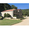 Parco Archeominerario di San Silvestro
Inaugurated on July 6, 1996, and extending over 450 hectares in the hills area north of Campiglia Marittima, the Park was born to valorise and propagate an extraordinary "open-air archive" where archaeological research has reconstructed the traces of a mining activity that began in the 7th century B.C. and continued up to the present day. The old restructured mine buildings at the entrance of the Park, house reception facilities, the Mineralogical and Archaeological Museum and the Mining Museum. The first houses a homogeneous collection of mineral finds from the area of Campiglia Marittima, collected between 1995 and 1996; the archaeological collection consists of stone, ceramic and metal finds from the excavation of Rocca San Silvestro, conducted between 1984 and 1992. The Mining Museum illustrates the evolution of mining technology in the Campiglia Marittima area. Particularly impressive are the remains of a medieval village, originally known as Rocca del Palmento (for the probable presence of an oil-press), which first belonged to the Della Gherardesca counts and later (12th – 13th centuries) to the Della Rocca family. This period marked the division of the village into functional areas: above, the genteel residence with the square tower and cisterns, near the church; to the west, the area of the furnaces for transforming the copper and argentiferous lead destined to the mint of Pisa, and the area for working iron, situated outside the walls. The untimely abandonment of the town, which occurred in the 14th century, admirably preserved its ancient features. Also very interesting, finally, is the Temperino Mine with its visiting itinerary that illustrates, on site, the millenarian mining activity that went on from the Etruscan period to the 1970s.
The San Silvestro Archaeological Mines Park is part of the Val di Cornia Parks system, made up of six parks managed by Parchi Val di Cornia S.p.A.
(Francesco Marchetti)
To document the renewed fortunes of mining activities in more recent times, the Val di Cecina offers two tokens of great scientific interest. The first consists of the Museo delle Miniere of Montecatini, a locality tied to the exploitation of copper and to the historical Montedison industry. You arrive there by continuing along Via di San Vincenzo, then taking SS1 towards Livorno, then turning onto SS68 and SP32 until Montecatini Val di Cecina.
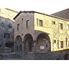 Museo delle Miniere di Montecatini
Despite the fortunes of the mining site can be set between the early 19th century and the early 20th century, the first documented news dates back to 1469 and continued, with changing fortunes, up to 1827 when – as historian and natural scientist Emanuele Repetti recalls in his Dizionario geografico fisico storico della Toscana - the exploitation of the mine was resumed. The town was undoubtedly a very important centre for the extraction of copper, so much indeed that it gave its name to one of the most important mining industries of Europe: Montecatini, later named Montedison.
The Museum is located in the historical Palazzo Pretorio (12th century, though restructured several times), seat of city government until 1953. Inside the loggia of the building is a plaque that compares the old units of measure with those adopted by the Decimal Metric System. The facade of a house opposite the palazzo has a marble sundial.
The Museum presents the documentation of mining activity between 1827 and 1927. It is part of a fascinating territorial exhibition circuit that illustrates the spots tied to the extraction of minerals. Among these, noteworthy is the site of Caporciano, the richest copper mine in Europe, with the entrance to the mine where the system of tunnels and winzes begins, the surrounding constructions, reserved mostly to administrative functions, and the porter’s lodge from which watchmen controlled the access to the mine and offices.
Proceeding along the road above the main entrance of the mine of Caporciano, we reach Pozzo Alfredo, the main site of ore extraction. Inaugurated in 1855 with its approximate 315 metres in depth, it joined the various levels of tunnels. The shaft was equipped with a steam machine fuelled by two boilers that extracted the ore and introduced the materials necessary for the miners’ operations.
Finally, the Muraglione dam performed the task of guaranteeing the mine’s water needs.
Admirably restored, the complex forms an efficient historical itinerary in the field of copper extraction from the technical-scientific viewpoint, as well as from the social perspective.
(Graziano Magrini)
To conclude your excursion, a detour at Larderello, 30 km from Montecatini, travelling SS439 through the salterns of Volterra, will take you to the area of the borax fumaroles and the Museo della Geotermia Enel tied to them.
 Museo della Geotermia Enel
«Monte Cerboli - as described by Grand Duke Peter Leopold of Lorraine - is a small manor of from 3 to 400 souls. A mile further on, and for a radius of a mile, in a grassy valley lie very large apertures and various fumaroles […]. Water no longer boils in many of them, while others are dry and only smoke; many are ponds with water boiling violently, and in others, the water noisily gushes forth to a height of 4 or 5 arms; in many, one can only hear the wind roar forth from underground. They are subject to constant change, and while some die out, other new ones are born».
The natural manifestations of the area of Larderello (lagoni, fumaroles and hot springs) were already known to the Etruscans and Romans, who utilised boron salts for pharmaceutical purposes and to prepare enamels. In the Middle Ages and the Renaissance, the thermal and pharmaceutical use of the waters continued.
Following the discovery of boric acid in the lagoni (mud volcanoes) of Volterra by chemist Uberto Francesco Hoefer, director of the grand-ducal pharmacies), the first attempts at economic exploitation were begun. The great anatomist Paolo Mascagni, born in Pomarance, supplied an efficient description of the lagoni: «Lagoni are plots of land in the areas of Volterra and Siena, which have larger or smaller dimensions, are without plant life, and have depressions containing water that boils more or less noisily, while a white cloud or varyingly dense steam rises from the surface, becoming smoke that disperses in the air and spreads a strong odour of liver of sulphur over a great distance. Because of this smoke, in several places they are called fumaroles, while in others, such as Viterbo, mud volcanoes».
In 1818, tradesman of French origin Francesco Giacomo Larderel set up near Montecerboli the first industrial nucleus for the production of borax. In the span of a few decades, thanks to continuous technical innovations, the borax industry became an advanced model on the industrial and technological panorama of Tuscany. So it was that in 1846, Grand Duke Leopold II of Lorraine paid homage to the founder of the borax industry by giving the name of Larderello to a town in the area. Other factories were built at Lustignano, Serrazzano, Monterotondo, Castel Nuovo, Sasso and Lago.
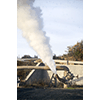
The fumaroles are currently utilised in the geothermal-electric energy sector. The first historical experiment in the production of geothermal-electric energy dates July 4, 1904 when a piston engine, driven by steam obtained in a heat exchanger, powered by a steam well at Larderello and connected to a 10 kilowatt dynamo, lit five light bulbs of a few watts each, which made it possible to verify that energy could be produced by means of geothermal fluids. In 1913, the world’s first geothermal plant was set up.
The history of the borax industry and of the industrial exploitation of geothermal energy has been reconstructed, thanks to a detailed and interesting iconographic, documentary and instrumental apparatus by the Geothermal Energy Museum, founded in 1956 by Larderello Spa. The origin of the Museum date to the small popular exhibition set up in Palazzo De Larderel in the late 19th century. Today, the property belongs to ENEL Greenpower Spa, and the Museum is housed in a temporary structure (a geodesic dome), while awaiting the conclusion of the restoration of Palazzo De Larderel.
The collection is made up of historical exhibits, datable from the mid 19th to the mid 20th century, tied to the exploitation of the borax springs. It includes samples of minerals and rocks, drilling machinery, electric power plant machinery, and various scientific apparatuses, including the instruments of the old Larderello pharmacy. The collection also comprises models concerning the development of the Larderello area, the extraction methods of boric acid, the drilling activities and the production of electric energy. It furthermore presents the company books, geological maps and documentation concerning (the) production activity. The Museum library and archive are on deposit care of the ENEL historical archive in Florence.
(Graziano Magrini)

****************************
Texts by Elena Fani
English translation by Victor Beard
Last update 01/feb/2008