- Michael of Rhodes

- Michael's Life

- A Mariner's Knowledge

- Journey Map

- Manuscript Viewer

- Glossary

- About the Michael of Rhodes Project


Navigation: Basic Navigation
Galleys sailed along the coastline whenever possible, and Michael's system of navigation was adapted to that context. No one part the system was sufficient by itself, but together they provided a basic method of navigating that was reasonably safe and secure, particularly when combined with the use of portolans and a mathematical technique known as the marteloio (Learn more about the marteloio.)
Most Venetian galleys, merchant and military, sailed in convoys in which the captain of the fleet's vessel was responsible for most of the navigation and the other galleys could follow it.
Line of sight
The basic method of navigating was by line of sight, which meant sailing along a coast from one recognizable landmark to another. This was perfectly safe as long as the weather was clear, and someone on board was aware of underwater hazards that couldn't be seen.
Experience
Since most navigation was by line of sight, experience was the most important tool a navigator could have. To recognize coasts and landmarks, one had to have seen them before. Since every voyage was a little different, the only way to truly learn a coast was to sail it several times, as Michael did on his multiple trips to Flanders, for example.
Experience was essential for a second reason, which can be hard to recognize now that so few people travel by water and even fewer travel by sail: namely, the constant danger. Medieval mariners were all too aware of how quickly wind and weather could change, and how even small mistakes could lead to death and destruction. It was therefore essential to have someone on board who knew how to read the weather for changing winds and oncoming storms; who knew the local coasts and currents and could anticipate the danger they might cause. The only way to master this knowledge was to spend years at sea. Michael gained more of this experience on every voyage he took.
Pilots
Experience of local conditions was so important that commercial galleys often brought aboard local pilots in addition to their own navigators. Experienced pilots knew the local winds, currents, and hazards and were particularly adept at entering local ports. No galley could enter the port of Venice without a pilot.
The windrose
Like all sailors, medieval mariners needed a way to designate direction. They did not divide the points of the compass into 360 degrees as we do. Instead, they used the windrose.
The origin of the windrose lies in the fact that prevailing winds in the Mediterranean are quite regular, while others regularly blow from certain directions at certain times of the year. From ancient times, mariners named all these winds and used them to indicate the directions in which they wanted to travel.
Following the introduction of the compass, sometime after 1200, the method of designating direction in terms of winds was standardized. The resulting system relied on the use of eight wind names. Although the names varied in different medieval texts, these are the versions Michael used:
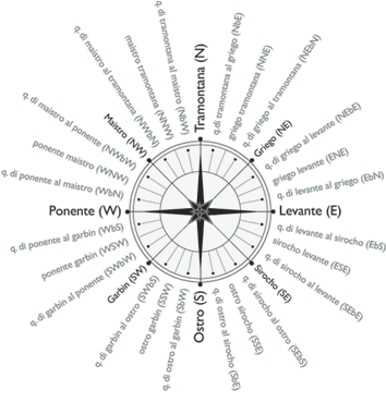
- Tramontana (North)
- Griego (Northeast)
- Levante (East)
- Sirocho (Southeast)
- Ostro (South)
- Garbin (Southwest)
- Ponente (West)
- Maistro (Northwest)
These eight names were combined in different ways to identify all the other winds.
The naming scheme was based on the idea that there were four "quarter" winds for each 45 degrees of the circle between each pair of basic winds—between levante and griego, for example. The direction midway between any two basic winds was designated by simply combining the two names. So the direction halfway between griego and levante was simply called levante griego, or griego levante; in this case, the order did not matter.
Not so with the other two quarters between griego and levante. They were carefully designated by a special expression in which the order of the names was crucial. For example, quarta di levante al griego was the quarter closest to levante, while quarta di griego al levante was the quarter closest to griego. The other pairs in the list of winds were treated the same way.
Unfortunately, Michael often drops the "quarta di" from his directions, keeping only the "al." Careful attention has to be paid to his text to distinguish between directions such as levante griego, griego al levante, and levante al griego.
All told, there were 32 named directions on the windrose, with eight quarters of 11.25 degrees between the cardinal points. These eight quarters would provide the foundation of the technique for navigating known as the marteloio.
The compass
Invented around 1200, the original magnetic compass was a crude affair, consisting of a magnetized needle stuck in a piece of straw that floated in a bowl of water. By Michael's time, it had become a standard piece of shipboard equipment, with a binnacle (housing), lantern, and a compass card with the windrose drawn on it.
The utility of the compass lay in the fact that it always pointed north, or at least to the magnetic north. Mariners could always use this fact to determine the direction in which they were sailing. The compass was particularly helpful on a cloudy night and in fogs or storms, when sight-based methods of determining direction were useless.
Oddly, Michael never mentions the compass, just as he never mentions the use of sea charts. Nor does he directly discuss navigation by celestial bodies. Yet the use of the compass in combination with the windrose is assumed in Michael's portolans, and was essential to the marteloio.